It’s been a busy and destructive start to Oregon’s wildfire season.
Two state parks have already been evacuated by fast-moving wildfires, 56 homes have been destroyed, and 20,300 acres have burned in more than 400 fires — mostly east of the Cascades.
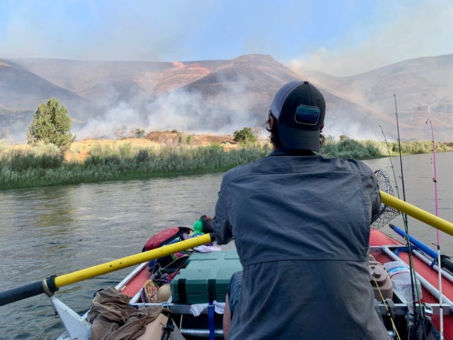
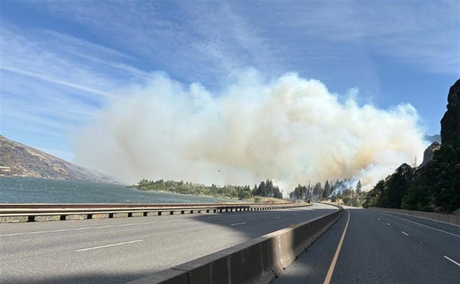
Rafters on the popular John Day River have twice found themselves floating through the middle of an active blaze. Residents of The Dalles have seen their neighborhood reduced to rubble. At one point, Interstate 84 was closed due to wildfire activity.
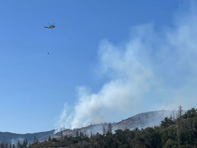
“What’s striking is the size of the fires we’ve seen this early in the season,” Oregon Department of Forestry wildfire spokeswoman Jessica Neujahr said. “It’s not unusual for us to have wildfires in June, especially on the east side of the state, but to have them this large and just back-to-back-to-back is unusual."
Neujahr said the fires also are an indicator of what to expect the rest of the season. High fire danger is expected to persist across the entire summer and into fall.
Major Oregon wildfires so far in June
The fires Neujahr referenced include the Rowena Fire (3,700 acres in The Dalles), the Ferry Fire (10,500 acres southeast of Wasco) and the Alder Spring Fire (3,442 acres northeast of Redmond). The Rowena Fire was human-caused and the cause of the other two remain under investigation.
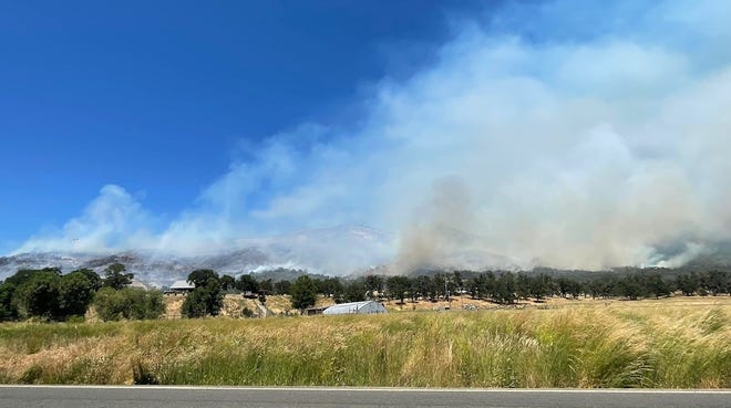
The Upper Applegate Fire roared to life, burning 470 acres and brought evacuations to the southwest Oregon town of Ruch on June 18. On June 19, the 5-acre Rice Fire prompted evacuations in Mapleton, located in the Coast Range.
Rain across Oregon could help bring reprieve
The good news is that rain and showers are forecast across the entire state through June 22. Upward of an inch is forecast for the Willamette Valley, and 2 inches is possible in the Cascade Range. East of the Cascades, about 0.2 to 0.4 inches is forecast.
“We’re hoping for a bit of a reprieve — a gap from the large fires coming one after the other,” Neujahr said. “But it certainly doesn’t mean we can get complacent.”
What’s been the cause of the large Oregon wildfires?
A combination of factors has led to the large wildfires seen so far this year. A wet winter led to the rapid growth of fuels like grasses in eastern Oregon, which then dried out rapidly under hot and dry spring conditions.
“The wind has been a major factor,” Neujahr said. “For the grass fuels, it takes winds of just 10 mph to carry that fire and spread. On the fires we’re seeing at Rowena (and Ferry), winds have been gusting over 30 mph.”
And, Neujahr stressed, many of Oregon’s early-season wildfires have been human-caused.
Oregon wildfire danger forecast to stay above-normal all summer
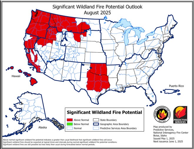
Wildfire danger is forecast to stay above normal all summer in Oregon and the Pacific Northwest, according to the National Interagency Coordination Center.
In July, wildfire danger will be above normal across the east side of the state, while in August and September, forecasts call for above-normal fire danger in every corner of Oregon, Washington, and Northern California.
The main reason is that forecasts indicate hotter and drier conditions than normal across the length of summer, combined with an elevated risk of thunderstorms arriving from monsoonal moisture in the southwest.
“We are preparing for what is likely to be an even more aggressive and increasingly difficult to control wildfire season this year,” Gov. Tina Kotek said at a May 7 news conference.
Oregon wildfire season hasn’t kicked into gear yet in western Oregon
While larger wildfires have started breaking out east of the Cascades, fire season on the state’s west side hasn’t kicked into gear yet.
And rain and cooler temperatures should help push off major fire season for a few weeks in the Willamette Valley.
Most of northwest Oregon moves into fire season at the end of June or early July, and that remains on track, Neujahr said.
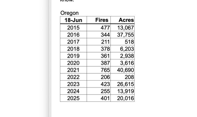
Oregon wildfire season by the numbers: Destructive, but not historic so far
The amount of acres burned so far this season, 20,300, is above the 10-year average of about 13,000 acres. It comes after Oregon set a record for the number of acres burned in 2024.
However, 2023, 2021 and 2016 each had more acres burned before June 18.
That said, none of those years had fires nearly as destructive as this year.
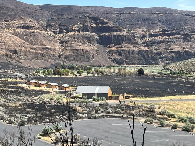
The Rowena Fire burned 56 homes and more than 90 total structures, while the Ferry Fire burned Cottonwood Canyon State Park. Alder Springs was threatening Crooked River Ranch and has brought evacuations and closures to Cove Palisades State Park.
What happened to Oregon being in amazing shape, drought-wise?
It wasn’t that long ago that climatologists were celebrating Oregon being free of drought and abnormal dryness for the first time since 2019.
Oregon has had above normal precipitation statewide, and the snowpack was in excellent shape all winter, leading to one of the best ski seasons in recent memory.
So what happened?
April, May and much of June have been warmer and drier than normal.
“That warm and sunny weather drove a ton of evaporation, which really dried out our soils,” state climatologist Larry O’Neill said. “It happened so fast that it’s almost like we didn’t actually have a good winter.”
Strong monsoon season a big wildcard
One of the most intriguing questions of the season centers on what happens in the Southwest.
NOAA has forecasted “above normal” chances for an active monsoon season in Arizona.
That matters for Oregon because during the summer heat, moisture from monsoons often travels north and causes thunderstorms.
The thunderstorms can be a blessing or a curse.
Sometimes, they bring storms with dry lightning that ignites hundreds of small fires, overwhelming even well-prepared crews.
At other times, they bring much-needed moisture that not only prevents lightning strikes from igniting wildfires, but also helps tamp down the ongoing wildfire season.
Both scenarios have happened multiple times the past five years.
“This year monsoon season is expected to come on stronger than usual,” John Saltenberger, the fire program manager at the Northwest Interagency Coordination Center, told the Statesman Journal in May. “Whether that results in wet or dry storms is always an open question.”
East wind events always the biggest wildcard for Oregon wildfires
While issues like drought, monsoons and warm temperatures can set the stage for wildfire season, the season really comes down to two key factors — lightning strikes and east-wind events.
Virtually all of western Oregon’s major wildfire blowups, including the 1933 Tillamook Burn, 2020 Labor Day fires and 2022 Cedar Creek explosion, have been fueled by major east wind events.
When Oregon gets them, and there are wildfires on the landscape, it tends to be a bad fire year.
When Oregon doesn’t get them, or they arrive at times when there aren’t fires on the landscape, the state can escape fire season in decent shape.